
Atlantic Yards Visualization in Google Earth
Living in the Prospect Heights neighborhood of Brooklyn, one of the biggest issues hanging over our community is the specter of Bruce Ratner’s planned “Atlantic Yards” development. By dangling the prospect of a glitzy new Frank Gehry-designed stadium (to be occupied by Ratner’s own New Jersey Nets), the pro-stadium minions have largely succeeded at convincing Brooklynites that it will be nothing but good for the community, and everyone should rally behind it. However, the stadium is just a small part of the whole plan, and this brings me to why you are seeing a post about this on invisibleman.
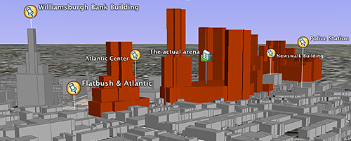
As a resident who will directly feel the impact of the development surrounding my home, I haven’t felt that I have seen an accurate portrayal of the sheer scale of this project, in the context of the existing neighborhood. Enter Google Earth.
I have been majorly geeking out over this amazing program for a few weeks now (as has my brother) , since they released a beta of the Mac version. One of the things you can do is place image overlays on top of the satellite imagery (like the PDF I used), and then draw polygons to extrude your own 3D buildings, knowing their heights (requires the use of the ‘Plus’ version, which is now available for both Mac and PC).
So I set up a placemark that will allow people to see this proposed development, to approximate scale (using the developers’ own figures), in context with the existing buildings. Also, make sure you check the “Buildings” checkbox below the viewer to see the heights of the existing buildings in grey.
So if you haven’t downloaded Google Earth yet you can do so here (both PC and Mac): DOWNLOAD GOOGLE EARTH.
Once you have that set up, you can download my Atlantic Yards placemark below…NOTE: if you click on the following link and get a garble of letters, just go back and right-click (control-click on the Mac) on the link, and save the file to your Desktop, then just double-click on the downloaded file.
DOWNLOAD THE ATLANTIC YARDS PLACEMARK
![]()
I actually work with the focus at Google Earth and so I see so many cool uses of this tool. That said, I must say this is so compelling. As someone who likes the idea of development in general and in that neighborhood, I can clearly see how this is every bit out of scale, too dense and way too aggressive a proposal. Phenomenal work!
Awesome. I can’t wait to go home and Earth it up. I’d love to see an extended version with 4th Ave rezoning and the Downtown Brooklyn / Flatbush upzoning included, so we could get the full effect, which I imagine will make it seem a lot more contextual.
Joel,
Isn’t your logic a bit warped when you use unbuilt structures to make the case for contextuality? I thought we could all agree that “context” refers to the present tense, not some speculative, overbuilt future. One can argue the merits of size forever, but if we use the “future” as our basis, than nothing will ever be out of context.
The only problem with this visualization is that it doesn’t show the existing tall buildings in downtown brooklyn. So it gives a distorted sense of the development in relation to it’s surroundings. On the record I think Ratner project is horrid, but this view of it isn’t an accurate way to judge it’s context.
I hate the whole idea of eminent domain, let alone a sports-complex, I can barely get down Flatbush as it is… moreover, I get sad that I might be out of a view of Manhattan or at least the clocktower.
That said, I do have some remarks/questions:
– Why are the new existing Atlantic Center towers left out (that will give me more context)
– Why do you show the back of Atlantic Center mall on the site. I’m not familiar with teh whole ownership issue, but I was under the impression he took over the existing mall from another owner. I also know that since this happens, the exterior has been changed (mucb for the better) and better stores were attracted. Even the aforementioned Atlantic Mall towers don’t look nearly as bad as many other buildings in New York.
– Could you please add some statistical info on height/floors/etc. for each building
Keep up the great work on your blog. Best wishes WaltDe
I am from Pittsburgh and this reminds me of the Hill District and our Mellon Arena. The arena cut that neighborhood off from the city and put it in a bad position. I am not an expert on the subject but if you should look it up. I think it might help your argument.
I like the 3d graphic
I enjoyed this post, l work for an seo company, but enjoy many areas
What a great post thanks
no